
Gothic Quarter
The city counted 1,322 shelters, and says the people dug most of them themselves
Under the squares of this city there is a second city, dug by hand between 1937 and 1939 by people who were not soldiers. Two of them are open, and the numbers attached to them disagree.
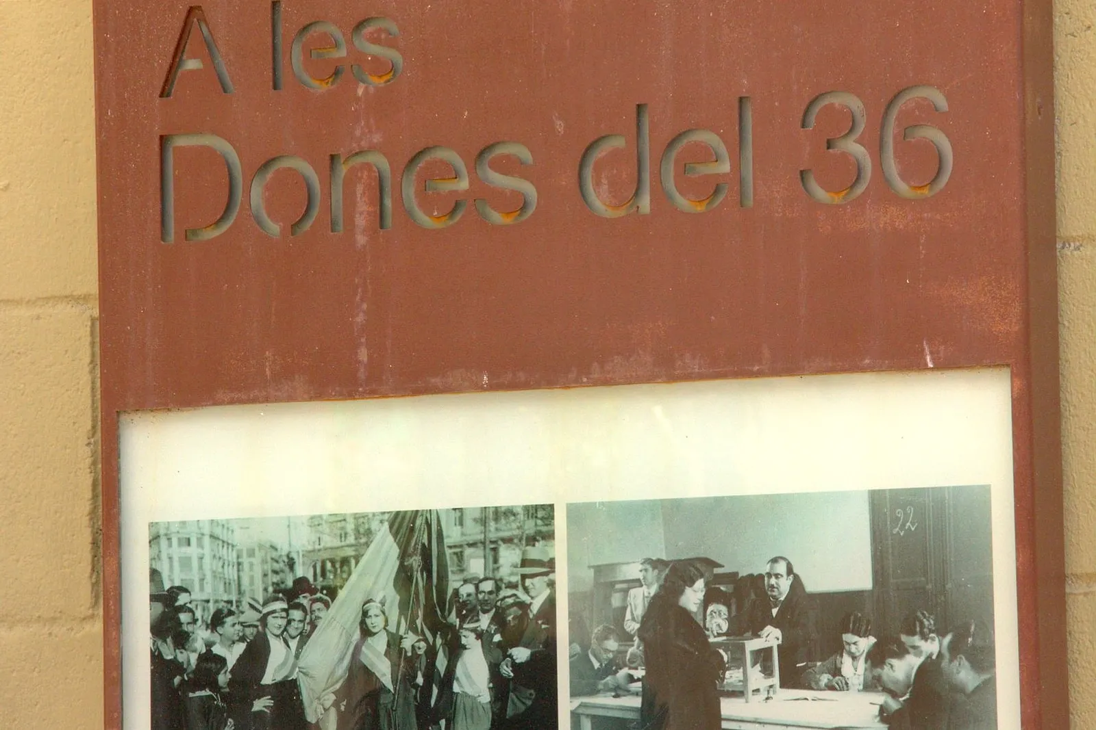
Barcelona was one of the first cities in Europe to be bombed from the air as a matter of policy, and it answered by digging.
What is under the squares of this city is not a metaphor. It is a second city, hand-cut between 1937 and 1939, and the institutions that hold the record are unusually honest about who did the cutting.
The number, and why there are three of them
The Ajuntament’s democratic memory programme:
During the Civil War 1,322 air-raid shelters were built in Barcelona.
The city’s archaeological register, describing the same thing from the other end: the passive-defence services subsidised around a hundred, and the rest, almost 1,300, began to be excavated in a self-organised and self-financed way. Note the verb — began to be excavated.
The city history museum, in English: one of over 1,000 bomb shelters.
Three arms of the same city, three figures. The one you will see most often on other pages is around 1,400, and it comes from adding the archaeological register’s hundred to its almost-1,300 — which counts shelters that were started, not finished. 1,322 is the inventoried figure and it is the one we use.
Who dug them
This is the part that changes how you walk around Barcelona.
The Ajuntament, about its own 1,322:
Of these 1,322 inventoried shelters, only 5 % were built directly by the institutions, while another 10 % received public subsidy. The rest were the work of self-organised civil society.
The archaeological register goes further and says who, specifically:
Their construction was owed to the selfless work of non-militarised civilians, the old and, above all, women and children.
And where they started digging:
They began in the neighbourhoods with a great associative tradition, and without compromising the foundations of the buildings — for example, in the public squares.
Two institutional accounts, incompatible in their arithmetic — one says about 7 % were institutional, the other 15 % — and identical in the thing that matters. Most of these were dug by the people who would be standing in them.
The sentence that reorganises everything
From the memory programme, and it is the single best line published about this subject:
The density of shelters does not correspond to the areas worst punished by the Aviazione Legionaria and the Condor Legion, but is directly linked to the associative fabric.
Read that twice. The shelters are not where the bombs fell. They are where the neighbourhood associations were.
Not a map of danger — a map of organisation. Where people already had a co-operative, a workers’ athenaeum, a residents’ body, a way of deciding things together, they dug. Where they did not, they mostly did not.
That is an extraordinary thing for a city to publish about itself, and it explains why Gràcia and Poble-sec are full of them.
The one you can go into
Refugi 307, in Poble-sec, on the lower flank of Montjuïc. It is a site of the city history museum.
The archaeological record says it began to be built in 1937 and had municipal subsidy. The museum’s guide says it was excavated thanks to the work of many neighbours of the Poble-sec quarter.
On the size, the museum contradicts itself in a way worth knowing before you arrive. The introduction to its own page says the shelter comprises nearly 400 metres of tunnels; the body of the same page, and the printed guide, say the project was for nearly 400 metres and that by the end of the war about 200 metres had actually been dug. The archaeological register agrees with the second version: 200 m of galleries preserved.
So: a 400-metre plan, 200 metres achieved. The gap between those two numbers is the war ending first.
Its projected capacity was 2,000 people, and the museum adds the detail that makes that figure land: it exceeded the official recommendations, which were one linear metre for every four people.
And it survived because it was overlooked. It is, the museum says, one of the few shelters not closed by Francoist troops. Afterwards it grew mushrooms, stored glass for a factory nearby, had shanties built against it, and was closed at the end of the 1960s.
We are not printing a street number. The museum’s text, the museum’s address block and the archaeological record give four different ones between them, and it is the sort of thing that ends with somebody standing outside the wrong door.
The one under a square in Gràcia
Under Plaça del Diamant — the square in Mercè Rodoreda’s novel — there is a shelter, and the archaeological record measures it precisely.
Sixty-nine metres long. Galleries 1.10 m wide and 2 m high. 75.90 m² in total. You reach it down zigzag stairs dropping about 12.50 metres from entrances on Carrer de l’Or, opposite numbers 8 and 10. It had two ventilation shafts, an infirmary and an electrical installation.
And it has a hole in it, in the most literal sense: three further galleries were in the project and were never built, because the Ajuntament never granted the concession.
It was surveyed after a residents’ platform obtained district permission in 1999. It is not a MUHBA site, and the record gives neither a construction date nor a capacity — the period bracket on its file is a generic one and it would be easy to misread as a build date. We have not.
It is one of the squares of Gràcia, and the neighbourhood it is in is exactly the sort the city says did the digging: a town with its own associative habits long before it was a district of Barcelona.
And one in the Gothic Quarter, which nobody mentions
At Plaça de la Vila de Madrid — the sunken square with the Roman burial road in it — there was a shelter too.
The archaeological record: during the Civil War an underground shelter was fitted out beneath some of the rooms and areas of the Santa Teresa convent that occupied the square. Its typology is given as de reaprofitament — reuse. The city dug into what was already there.
It was documented from the list of shelters of 16 July 1938, published in the Atles dels Refugis, and archaeological work on it ran from November 2000 to July 2003.
So that one small square holds a Roman cemetery of the first to third centuries and a 1938 shelter, on top of each other, and the railings you look through only tell you about the first.
The bombing, and the numbers that do not add up
Two institutional accounts, measuring different things:
The archaeological register. From the first attack on the urban core — a naval one, on the night of 13 February 1937 — to the fall of the city, Barcelona suffered 194 bombardments, most of them aerial. It gives no death toll.
The memory programme. Between 13 February 1937 and 25 January 1939, the city took 1,903 impacts and more than a million kilos of bombs, causing more than 2,700 dead and 7,000 wounded. It gives no raid count.
No single institution publishes both. If you find a page that pairs a raid count with a death toll, somebody has stitched two sources together. And note the start date: both institutions begin at February 1937, not 1936. A headline saying “the bombing of Barcelona, 1936–1939” is not supported by either of them.
The days everybody has heard of — 16, 17 and 18 March 1938 — are confirmed as dates by the Ajuntament. What is not published, anywhere we could reach, is a casualty figure for those three days specifically. So we do not have one.
A correction to our own pages
This journal exists on the claim that what we write can be checked, which means saying it out loud when the check comes back against us.
Several of our pages have said that at Plaça de Sant Felip Neri on 30 January 1938, a second bomb fell on the people who came to help. It is repeated everywhere, and the Ajuntament’s own memorial page for that square does not say it.
What the page does say, in its own English:
Barcelona was continuously bombed on the morning of 30 January 1938, from 9 am to 11.20 am, by Franco’s ally, the fascist Italian air force.
The bombs levelled the church, burying the children who had sought shelter in its basement. Some twenty died.
Forty two people were massacred that morning and over a hundred wounded.
The aerial bombings went on non-stop, the bombs hampering efforts to evacuate the site.
The bombing went on and the bombs hampered the evacuation is not a second bomb fell on the rescuers. It is close, it is worse in some ways, and it is a different sentence. We have taken ours out and replaced it with theirs.
The rest of the city’s account stands, including the part it is most important to keep repeating: for decades the marks on that wall were explained as bullets from firing squads executing priests, a version the Ajuntament describes as Francoist propaganda that covered up their part in the massacre.
How to see any of this
There is no official route. We looked, and what exists is the city’s archaeological register and its open dataset, which anyone can consult record by record, and one museum site you can walk into.
Which is, in a way, the right condition for it. The shelters were not built as monuments. They were built in three days by people who had a shovel and a square, and most of them are still under the pavement doing nothing.
Refugi 307 is a twenty-minute walk from the foot of Montjuïc, which makes it easy to attach to a hill afternoon — see how to get to Montjuïc and is Montjuïc worth it. We are not printing its opening arrangements; the MUHBA publishes them and they change.
Why our walks touch this and do not dwell on it
Our Gothic Quarter walk passes Sant Felip Neri and stops there, briefly, and tells it the way the city tells it — with the propaganda version named as a propaganda version, and without the sentence we have just removed. The after-dark version goes through the same square when it is empty, which is when the marks read for what they are.
Our Montjuïc walk climbs past the neighbourhood that dug Refugi 307 on its way to a castle that had its own part in all this and to the quarry where some of the people killed in raids like these are buried.
Neither dramatises it. There is nothing here that needs help.
The square that most people associate with the raids has its own page, including what the city does and does not say happened there: Plaça de Sant Felip Neri. And the neighbourhood that dug Refugi 307, on the flank of Montjuïc, is Poble-sec.
Where this comes from
- Refugis antiaerisAjuntament de Barcelona · Regidoria de Memòria DemocràticaThat «during the Civil War 1,322 air-raid shelters were built in Barcelona»; that of those 1,322 inventoried «only 5 % were built directly by the institutions, while another 10 % received public subsidy» and the rest were the work of self-organised civil society; that «the density of shelters does not correspond to the areas worst punished by the Aviazione Legionaria and the Condor Legion, but is directly linked to the associative fabric»; that between 13 February 1937 and 25 January 1939 the city took 1,903 impacts and more than a million kilos of bombs, causing more than 2,700 dead and 7,000 wounded; and the dates of the raids of 16, 17 and 18 March 1938.
- Refugi 307Ajuntament de Barcelona · Carta Arqueològica (Servei d'Arqueologia, ICUB)That Refugi 307 «began to be built in 1937 and had municipal subsidy», and that some 200 metres of galleries are preserved.
- Refugi antiaeri de la plaça de la Vila de MadridAjuntament de Barcelona · Carta Arqueològica (Servei d'Arqueologia, ICUB)That during the Civil War an underground shelter was fitted out beneath some of the rooms of the Santa Teresa convent that occupied the square; that the passive-defence services subsidised «around a hundred» shelters while the rest, «almost 1,300, began to be excavated in a self-organised and self-financed way»; and that the building of them was owed to «the selfless work of non-militarised civilians, the old and, above all, women and children», starting in neighbourhoods with a strong associative tradition and in public squares so as not to compromise the foundations of buildings.
- Refugi antiaeri de la plaça del DiamantAjuntament de Barcelona · Carta Arqueològica (Servei d'Arqueologia, ICUB)The measurements of the Gràcia shelter: 69 m long, galleries 1.10 m wide and 2 m high, 75.90 m² in total, with zigzag stairs dropping some 12.50 m from entrances on Carrer de l'Or; that three further galleries in the project were never built because the Ajuntament never granted the concession; and the two ventilation shafts, the infirmary and the electrical installation.
- Refugi 307Museu d'Història de Barcelona (MUHBA)That it is «one of over 1,000 bomb shelters built in Barcelona during the Spanish Civil War», and that the Republican Army, the Generalitat, the City Council and the people of Barcelona all played a part.
- Guia del Refugi 307 (PDF)Museu d'Història de Barcelona (MUHBA)That the project «consists of nearly 400 metres of tunnels» of which some 200 metres had been excavated by the end of the war; that the projected capacity was 2,000 people, exceeding the official recommendation of one linear metre per four people; that it was excavated thanks to the work of many neighbours of Poble-sec; and that it was one of the few shelters not closed by Francoist troops.
- Plaça de Sant Felip NeriAjuntament de Barcelona · Programes de Memòria DemocràticaThat Barcelona «was continuously bombed on the morning of 30 January 1938, from 9 am to 11.20 am»; that the bombs «levelled the church, burying the children who had sought shelter in its basement. Some twenty died»; that «forty two people were massacred that morning and over a hundred wounded»; and that «the aerial bombings went on non-stop, the bombs hampering efforts to evacuate the site» — which is the wording that made us correct our own pages.
Everything above that carries a date, a figure or a name is checked against these before it is published. Where we could not find a source, the page says so.
Quick answers
- How many air-raid shelters were there in Barcelona?
- It depends which arm of the city you ask, and we are giving you all three. The Ajuntament's democratic memory programme says 1,322 shelters were built during the Civil War, and calls them inventoried. The city's archaeological register describes around a hundred subsidised shelters plus almost 1,300 more that people began to excavate on their own account. The MUHBA says over 1,000. Nobody publishes 1,400 as a completed figure.
- Who built Barcelona's air-raid shelters?
- Mostly the people who used them. The Ajuntament states that of the 1,322 inventoried, only about 5 % were built directly by institutions and another 10 % received public subsidy — the rest were the work of self-organised civil society. The archaeological register is blunter about who held the shovel: non-militarised civilians, the old, and above all women and children.
- Can you visit an air-raid shelter in Barcelona?
- Yes. Refugi 307 in Poble-sec, at the foot of Montjuïc, is a site of the city history museum and is open to visitors. Check the MUHBA's own pages for current arrangements. The shelter under Plaça del Diamant in Gràcia is a different case: it was surveyed after a residents' campaign in 1999 and it is not a MUHBA site.
- How big is Refugi 307?
- Smaller than it was meant to be. The museum's account is that the project envisaged nearly 400 metres of tunnels and that by the end of the war about 200 metres had actually been excavated — which is what survives. Its projected capacity was 2,000 people, a figure the museum notes exceeded the official recommendation of one linear metre for every four people.
- How many times was Barcelona bombed?
- The city's archaeological register counts 194 bombardments, from the first attack on the urban core — a naval one, on the night of 13 February 1937 — to the fall of the city in January 1939. The Ajuntament's memory programme, over almost the same period, gives 1,903 impacts, more than a million kilos of bombs, more than 2,700 dead and 7,000 wounded. No single institution publishes the raids and the deaths together, so treat any page that pairs them with care.
- Is there an official map of Barcelona's shelters?
- Not a standing one. What exists is the city's archaeological register and its open dataset, which anyone can consult, and which carries the individual shelter records with their measurements. There is no published walking route of surviving shelters.
The tours this piece is about
The Gothic Quarter: a neighbourhood that invented itself
Barcelona's most photographed bridge dates from 1928.
- How long it lasts
- 2 h
- Runs in
- EN · ES · CA
- Price
- 15 €
Never more than 20 people
The Gothic Quarter after dark
By day it is a crowded stage set. By night it is a narrow city.
- How long it lasts
- 2 h
- Runs in
- EN · ES · CA
- Price
- 18 €
Never more than 20 people
More in the journal
The Gothic Quarter
- El Call: four streets, a stone that is a copy, and an argument about one building
- Asked which visitors they would like more of, Barcelona picked the ones who come to learn something
- It was a watercourse with a city wall on one side and convents on the other
- Barcelona has the first documented giant in Europe, and almost everything that walks today was carved after 1987
- The square is called Royal because of a monument that was never put up
- The engineer everyone credits with the Barceloneta designed a neighbourhood that was never built